| Attention | Topic was automatically imported from the old Question2Answer platform. | |
| Asked By | BigDC |
Godot 3.3
Game Type: 2D
For OS: Windows
Hello I am creating a Grand Strategy Game similar to Risk, Civ V, Hearts of Iron and others. I am using an image with each territory/region represented as a different single color. The problem is, I do not know how to make each territory/region selectable (clickable) and change that selection to white (or whatever color). Also I am wanting all the territories to be green (or whatever color) when the game first starts and the users sees it, as well as having each territory/region having a black outline
I have included an image that has 4 map images on it (ignore the white color that is just to help show separation in the map images). Hopefully this helps some.
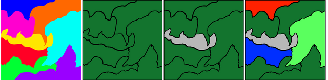
Images
#1. Base map image, each single color represents a single territory/region. User never sees this base map,
#2. The map the actual user will see (notice that each territory/region has a black border around it). Also no one owns (conquered) any territories/regions yet.
#3. A territory/region a user clicks on (selects( The selection is gray. Also no one still owns (conquered) any territories/regions yet.
#4. Some territories/regions are now owned (conquered) now by the Red, Blue, and Light-Green armies. The user is also selecting a territory/region as indicated by the gray color selection.
The territories/regions colors and the owners are store in 2 separate json files
territories.json
[
{
“id” : 1,
“color” : [0, 100, 100],
“owner” : 2
},
{
“id” : 2,
“color” : [255, 76, 63],
“owner” : 1
},
…
]
owners.json
[
{
“id” : 0,
“color” : 19, 116, 146]
},
{
“id” : 1,
“color” : [0, 0, 255]
},
…
]
All the territories are dark green with a black border around them at run-time, their actual single colors comes from the territories json file and which the user never sees it as depicted in Image #1,the dark green color as depicted in Image #2 comes from the owners json file with the ID of 0 indicating no owner, .So when a user clicks an area it turns gray as depicted in Images #3 and #4 to show that it is selected, once it is owned (conquered) depicted in Image #4 it’s color changes to reflect the owner who’s color comes from the owners.json file . This is what I don’t know how yo accomplish and need help with, please??